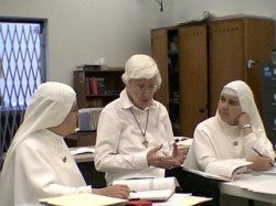
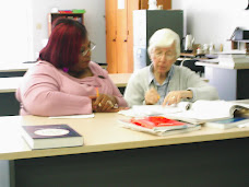
 (At left are students in our geography class here at SVDP-ALC, gathered around a map of the world.
On the wall above my desk, way in the back right corner of the room, is a map of Antarctica. Our students are learning all about that fascinating continent. Next to that is a poster about a "Second line" in the 9th Ward in New Orleans; a Second Line is a type of Jazz parade in New Orleans with music and dancing in the streets.
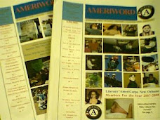
Below is an article I wrote for "AmeriWord," the newsletter of Literacy*AmeriCorps. It is about our regular geography class here at SVDP-ALC, and it is re-printed here with permission of "AmeriWord.")
Learning with Maps
By Adrian McGrath
Last month we began a new teaching session at our site at the St. Vincent de Paul Adult Learning Center in New Orleans which we call “map skills” or “map reading” class. Although initially the main focus of the session was basic geography, our class soon learned that many other subjects became involved and many opportunities arose for open class discussions during the sessions. And although the sessions were originally designed to have a lecture format, we soon found that they naturally evolved into interactive sessions with much student input that resulted in greater student interest. So, I thought it would be worthwhile to share with our readers some of the things we covered and what we learned and experienced.
I began with a plan to teach basic geography with four maps – a road map of the city of New Orleans, a map of the state of Louisiana, a United States map, and a world map. Beginning with the Louisiana map, I opened the map on a large flat table, gathered the students around the map, and began asking questions. “Where is New Orleans, where is Baton Rouge, where is Lafayette, where is Alexandria, where is Shreveport and Monroe?” I started with. The students looked at the map and began identifying the locations. Then I went to smaller towns in the state. “Where is Houma, where is Amite, and Grand Isle?” I asked. Again the students responded, this time with greater interest. Sometimes they would stand up from their chairs and start pointing to places on the map.
Then I explained how to use the various charts and tables along the sides of the map which help to locate towns and which explain the various symbols and colors on the map. These charts also help to measure distances between cities. So then this led to a whole new skill in map reading which was the mathematical measurement of distances. How far is New Orleans from Lafayette?” I asked. “Somebody please tell me.” The students responded with great interest, using the various charts to help locate the cities on the map grid (which has letters and number coordinates) and then using math skills to determine distances.
The session went very well, and I discovered that basically two maps could be covered well in a 45 minute session. So, I began by selecting the remainder of my four basic maps, but also used other maps which I had accumulated over the years from National Geographic (which somehow survived Hurricane Katrina) plus other maps which Sr. Lory Schaff, our site supervisor, donated to the cause.
When we came to the USA map and the world map, these naturally led to brief discussions of either current events or historical commentary. For example, one student had just read about Napoleon Bonaparte in an English grammar text. So, we were able to show where Napoleon had gone on his various campaigns from France to Russia to the Isle of St. Helena into exile.
The most extraordinary session occurred during the week before Martin Luther King, Jr. Day. We used a small booklet which described the life of Dr. King, and asked the students to read a passage out loud from the book. Whenever the name of a location, city, state, etc. was named, we briefly stopped and pointed on the USA map to where Dr. King was at the time. “Where is Atlanta, where is Birmingham, where is Montgomery, Washington DC?” I would ask. But now we would discuss not just where these places were but what happened there and why. The world map quickly came into play when we reached the part in the story where Dr. King was awarded the Nobel Peace Prize. “Where is Oslo, Norway?” ‘What happened there?” Finally, tragically, we had to discuss where Memphis was and what happened there too.
We also took a short time to have the students express their views on what Dr. King’s life meant to themselves and their country. So, all these learning experiences could arise from what was originally meant to be a simple geography class.
Many other leaning opportunities could come from map skills sessions as well, for example, students could be asked to write an essay about the places they have “visited” in map class. For instance, we looked at maps of the Middle East including Iraq and Afghanistan which are so much in the news. And the most exotic place we studied in our map class was the frozen continent of Antarctica. The students were fascinated by a lost world at the bottom of the globe which has extreme temperatures and appears to be almost from another world.
And our study of Antarctica led us to the actual study of other worlds as we examined briefly photos and diagrams of the planets in our solar system including Mars, Venus, Saturn and so forth. Antarctica and the other planets naturally gave way to a discussion of science.
So from starting with four basic maps, we went on to cover subjects such as math, science, history, political science, and many other topics.
I would very much recommend map skills sessions as a way to help students learn both geography and a host of other subjects too.
Posted by Adrian


